Decennalia

An expanded shot of the blog's banner, a gargoyle of the Chrysler Building overlooking Manhattan

It’s January 30, 2025. A special date for this blog, as it marks the ten year anniversary of its launch. I’m a melancholic sort who often ponders the meaning of life and how short mine is, but as I reflect on the past decade I feel good about the work I’ve done here. Sure, for half of it I didn’t really make any posts, and some days my college years feel so very long ago. But it’s only been ten years since I was a sophomore! That’s not so much time, right? I’m still young… right?

Reading through my blog posts for the first time in a decade or so, I’m struck by how little my writing seems to have changed. Sure, I’ve got more life experience than the already-jaded college student who started this blog, but I feel my outlook on life and sarcastic writing style remains the same. I find myself not cringing at my younger self’s thoughts and opinions, a true luxury these days in a post-social media world. I think I might even have gotten along with past me, something else I imagine few can say. Sure, he could be an insensitive fool at times but that’s true of 2025 Ross as well, so… Can’t fault him too much for that.

But maybe ten years really is a long time. And maybe when something has lived that long, it’s time for a change. This blog has maintained its simple, Art Deco appearance for all of those years, and I feel like it deserves an update if I’m going to continue pouring creative effort into it. And thus, I have begun giving this site a fresh coat of paint, something that I hope will evolve it into an enhanced visual experience and submersion in the 20th century style and feel I want this blog to evoke. You may have also noticed the site has its own domain, no more .wordpress.com! For a year, anyway. Domains + hosting are expensive.

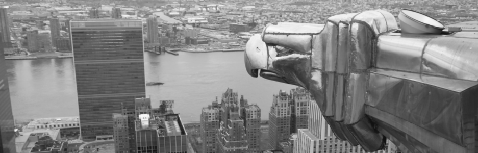
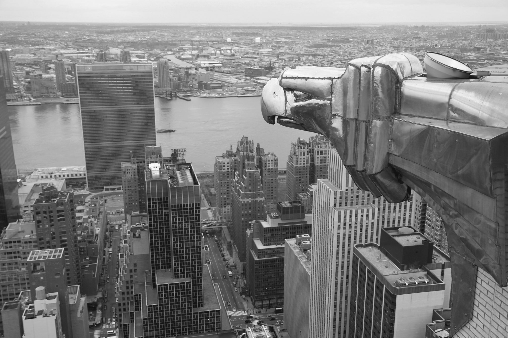
To honor that style I’ve loved for so long, let’s take a short journey through the architectural masterpiece that inspired my young, creative brain to the point where it has become a constant fixture in my mind as much as it is one on the New York City skyline: The Chrysler Building.

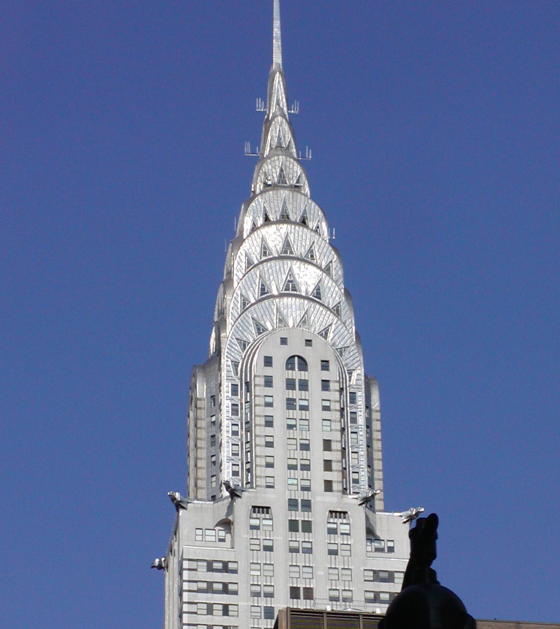
Now much has been said about this piece of art, so instead of writing a long history of the architect, the installation, and the broader details of what make it so brilliant (should be obvious), I’m just going to share some interesting facts and cool things I’ve gleaned over the years. The images are almost entirely from an amazing book I’d love a hardcover of – The Chrysler Building: Creating a New York Icon, Day by Day. Lots of cool shots of the building during its construction, which were almost lost to history when the author accidentally stumbled upon them as they were about to be destroyed.

Construction up to the 36th floor – July 12, 1929

Firstly, I’ll share something that came to my knowledge recently. On the 71st floor of the Chrysler Building was a public observation deck which – though closed since 1945, was a marvel of modern design. A gallery called “The Celestial” had breathtaking, one-of-a-kind solar system adornments and a spacefaring vibe that would have absolutely made the feeling of looking across the blossoming Manhattan skyline something truly resplendent.

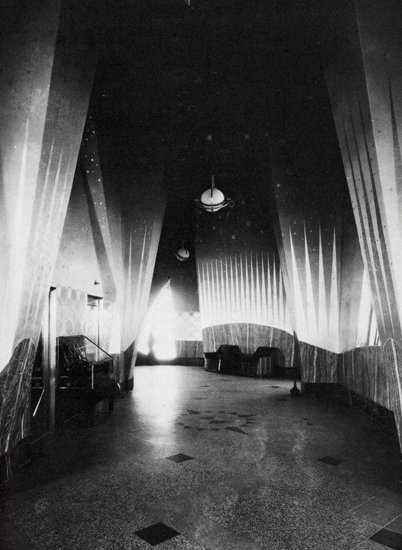
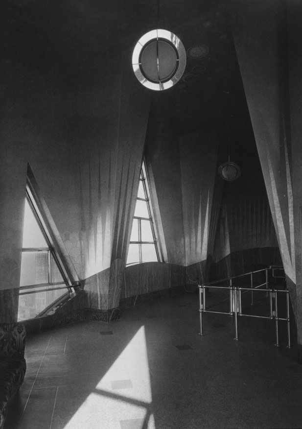
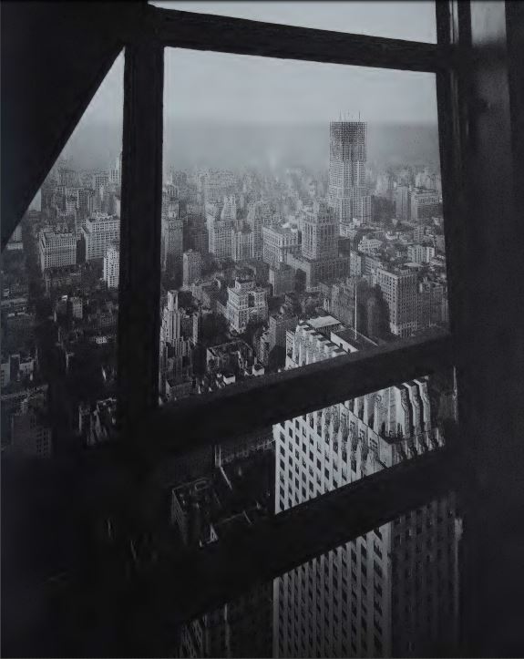
Gorgeous stuff – if only there were more photographs of this floor. Alas, it was closed in 15 years after opening and destroyed thereafter. Now the room is taken up by some soulless corporation instead of being open to the masses. If we can’t get it back for the people, I’d settle for it being my personal penthouse at the very least.

There was also a gentlemen’s club – more accurately a “millionaire cronies of Walter Chrysler club” that, in contrast to its Art Deco exterior, was decorated with a mishmash of a more traditional look & feel. Texaco, a tenant of the building, requested that a lunch club for executives be added to the building, and thus floors 66 – 68 became a strange amalgamation of medieval, Tudor, and modern styles so it could be more palatable to the traditional old dudes who would frequent it, much to the perturbation of the architect. The Cloud Club was not as short lived as the celestial – stuff for the rich elite always has a longer lease on life – but it did finally close in 1979 due to a lack of executive interest.

Photo from NYPL Collections

You can also view a cool gallery of club images here, as it looked later in its life.

Something that might initially look silly but then become familiar, in our ongoing age of pointless extravagance and performative opulence, is this shot of the architects of several famous high-rises dressing up on stage as their own buildings. Their outfits and headwear wouldn’t be out of place on a runway in Milan in [present year], methinks.

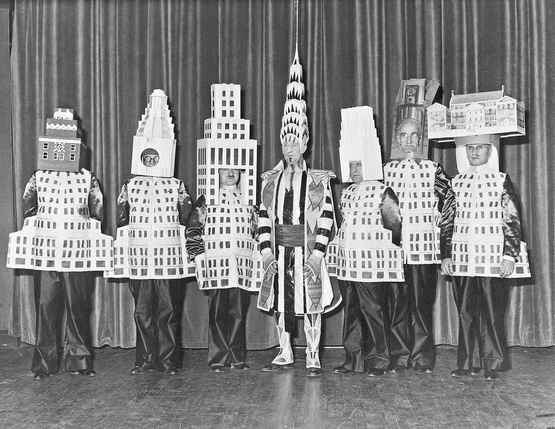
Here you can also see a short video of the men milling about on stage, looking a mixture of amused and confused.

Finally, I would be remiss if I didn’t share an incredible mini-documentary video with you. Narrated by John Malkovich, who is as big a fan of the building as I am, it is a very amusing and educational 10 minute romp. Whoever wrote it – I wouldn’t put it past the writer of some of it being Malkovich himself – has exactly the kind of sharp wit I like. Do yourself a favor and check it out – the video is screwy and repeats itself after the end, so you can close it around 10 minutes in. Enjoy!

Here’s to another decade of this blog. I have found it most entertaining to write, and I’ve learned quite a few things because of it, and we all know how much I love to learn. As I mention in my About pages, Cineri Gloria Sera Venit’s founding principle is to marry useful, interesting knowledge with a witty, entertaining presentation style. And, according to my three readers who all may or may not be related to me, I succeed in that endeavor. So why stop now?

The Undersea Freeway

Have you ever wondered what it would be like if a road existed that spanned the entire Atlantic ocean? A way to get to Japan from the state of Washington? What about a direct path from California to Australia, South Africa to Brazil, or even Florida to Spain?

The cost would be immense, wouldn’t it? After all, those places are all separated by vast oceans, thousands of miles of deep, treacherous waters. Physically connecting those places would be expensive, impractical, and not worth the difficulty when alternatives like flying and sailing exist. But… what if I told you those roads already exist? That they have been working and operational since the 19th century? That routes between those places and many, many more are the reason you are able to communicate with countless people all over the world, and may in fact be the reason you are able to view this post right now?

Well I am telling you that, and I’ll stop asking questions meant to draw you into this post. Now these roads might not look like you would imagine. Nor do they allow humans to travel over them – not physically anyway. Nevertheless, they are very real and do physically connect many parts of the world in a way that nothing else can.

It all began in 1858 when a cable was laid on the ocean floor that would become the foundation of a network spanning over 500,000 miles of physical, underwater cables. The tale of how this cable came to be born, live, and die is quite an interesting one, which you can read about here (for the modern summary) and here (for the original series of newspaper articles on it from the 1800s). Or you can ignore both of those and read my retelling here.

 After Samuel Morse’s brilliant invention of the telegraph had taken the world by storm and would be known as the greatest human advancement until sliced bread came around, an entrepreneur named Cyrus Field decided that the technology could be pushed further.

CyrusField
Cyrus – Millionaire, dreamer, ladykiller

The guy had retired at 34 with over 7 million dollars (2018, adjusted for inflation) so he clearly had a lot of free time to invest in pet projects. A Canadian engineer by the name of Frederick Gisbourne came to him, seeking an investment for a dream. Frederick had taken a look at the 20,000+ miles of telegraph lines spanning the United States of America and thought: “That’s cool, but what if we took these cables…. and put them underwater?”

Now Frederick had put his underwater cable theory into practice a few years earlier, connecting Prince Edward Island and New Brunswick. But this undertaking would have a vastly greater scope and significance. Instead of ~10 miles of underwater cable connecting two parts of a single country, his new idea was to connect Newfoundland, New York, and Ireland in a venture which would spawn the first continuous line of communication between countries separated by ocean. These locations were chosen because of a narrow plateau that existed between Ireland and Canada which would make laying the cable as well as maintenance slightly easier.

Cyrus and friends secured the aid of British investors, and together plans were made for this historic cable’s creation. The original attempt to lay the telegraph line was carried out by two ships, the American frigate Niagara and British warship Agamemnon. Both were loaded with over 1,000 tons of cable and sent on their merry way to the center of the Atlantic Ocean.

TransatlanticCableShips
The ladies Niagara and Agamemnon. Source: Frank Leslie’s Illustrated Newspaper, 1858

To make a reasonably-sized story short, Niagara and Agamemnon failed four times to lay the cable. Things like extreme storms and numerous cable breaks set the venture back time and time again. But Cyrus and his friends remained undaunted. In a move that would be hailed as the very definition of perseverance in the face of adversity, a fifth attempt to lay the cabling was made in July, 1858. By the beginning of August, it was completed successfully. Communication without the use of boats was now possible across the ocean. President James Buchanan and Queen Victoria even exchanged telegrams using the lines. Quite a historic moment. Hans Christian Andersen even wrote a fairy tale about it.

Now, thanks to a variety of factors, this cable was in service for less than a month. It was decommissioned and left unrepaired while engineers went back to the drawing board.  This transatlantic telegraph had proved that the ocean was not an obstacle that could never be overcome. As long as the cables were strong enough, insulated enough, and powerful enough, the entire world could be connected to light-speed communication.

Let’s fast-forward a hundred years later. Ever since the early 19th century scientists had envisioned using light, instead of electricity, to send communication signals. As technology slowly improved over the decades, advancements were made that further encouraged researchers to look into finding a viable way to transmit data this way. In 1966 A team of British researchers at Standard Telecommunication Laboratories finally figured out that by using a very powerful laser and extremely pure glass thread, fiber optic technology was within humanity’s reach.

Fiber optics! Techopedia defines this miracle as “[T]he technology and medium used in the transmission of data as pulses of light through a strand or fiber medium made of glass or plastic…” Boiled down even simpler, thanks to those researchers, high speed communication via flashing lights was now proved to be possible. What does this have to do with underwater communication cables? Quite a lot. You see, fiber optic cables were developed soon after STL’s breakthrough, which are (you guessed it) extremely long tubes of glass that can transmit these pulses of light vast distances, nearly instantaneously. Now you see where we’re going with this. I could talk for a long time on fiber optics, but that would be more than enough material for another article.

Long before this tech had been developed, many underwater telegraphs were successfully laid thanks to the pioneering effort of the Newfoundland-Ireland line. Thus, once fiber optics were perfected to the degree that a single line could span hundreds of miles, it only made sense to piggy-back off of Morse and Gisbourne’s designs and use them to create a new way to transmit data. Of course, they would have to be carefully constructed to ensure they wouldn’t break in a month or two. Below is what modern fiber optic cables built to withstand the ocean look like.

FIberOpticCableInside
Source: Telegeography.com

As you can see, the actual glass optical fibers are very small. A single strand is about the width of a hair. This allows for excellent flexibility – you wouldn’t want them cracking 27,000 feet below the surface. They still need quite a bit of protection, however. steel and copper sheathes surround the glass, with various materials insulating the line from the harsh ocean. Finally, several thick layers of specially crafted yarn form the outer shell of what is now a still pretty small cable. Considering that companies are paying for hundreds of thousands of feet of this cable, I’m sure they want them to be as small as possible to cut down on cost while still transmitting vast amounts of data at a high speed.

Today it is estimated that over 400 cables are lying underneath Earth’s oceans, spanning over half a million miles! If you want to see a really cool map of all the cables in existence today, look no further than submarinecablemap.com. This website is really, really great if you want a visualization of the vast effort that has been put into allowing you to read this article on your computer, phone, or tablet. If you think satellites were how you navigate the web, you were wrong. These babies are what handle the bulk of communication across the world. It’s truly an amazing thing. And to think it all started from the telegraph. In the span of less than 200 years we’ve taken our international communication methods from sending ships with letters to sending pulses of light over roads laid on the ocean floor.

I’ll leave you with a short, two-minute video from Business Insider that summarizes some of what I’ve talked about, as well as pointing out some interesting factoids about the process of laying down the cables. It’s a good, bite-sized chunk of information on a massive, astounding subject.

Bermuda Triangle

The Bermuda Triangle. Everyone’s heard of it, everyone knows its reputation. A mysterious section of ocean that has a penchant for swallowing ships and aircraft alike in its insatiable hunger. Unexplainable disappearances are on the menu every day at the Triangle, and by golly the Atlantic Ocean is ready to deliver.

But how many of the terrifying rumors that surround this three-pointed enigma are true? For how long have these supernatural events been going on? Can modern science finally explain the legend of the deep?

Well yes it can, and studying up on this phenomenon was quite interesting for me. Like most people, I’ve heard tales of the Bermuda Triangle ever since I was little, but other than their increasing my desire to never get on a boat in waters deeper than my local pool I didn’t pay much attention to them. However, recently I decided to do some diving into the lore surrounding the zone and see what today’s maritime opinion on it is.

The first thing to explain is the geography, and with it, the first known mention of the Bermuda Triangle in print. Its apparently unusual effects and rough dimensions were laid out by a reporter for the Miami Herald in 1950. In the article he wrote he made many claims, among continuous mocking of the modern-day belief of a “small world,” of several unexplained disappearances of commercial ships and airlines within the boundaries of Bermuda, Puerto Rico, and Miami. 

Bermuda Triangle Original Map
Original E. V. W. Jones map published with the Miami Herald article “Sea’s Puzzles Still Baffle Men In Pushbutton Age”

In this map we can see the lines that would form the boundary of the Triangle. Though Edward Van Winkle Jones (who had really mean, folk-tale loving parents apparently) never actually gave it the name “Bermuda Triangle,” his article clearly inspired all the writers and sensationalists who came after, reveling in the sense of mystery and terror exuded by this patch of ocean. It’s a pretty entertaining piece as well, and short. Really instills a little bit of fear in you and I bet it made more than a couple people rethink their travel plans that year. But let’s be honest, I doubt any travel over thousands of miles of ocean was safe in the ’50s. Between the choice of a Douglas DC-3 or a rusty bucket more prone to sinking than the Titanic I would probably gladly pick a raft built out of rocks by the Flintstones.

Knowing where the three vertices of this area of doom lie is only half the story though. We want to hear more about these disappearances. If there really has been a disproportionate number of flights and fleets gone without a trace, then perhaps there really is something to these rumors after all.

The actual phrase “Bermuda Triangle” was coined in 1964 by William Gaddis in his article “The Deadly Bermuda Triangle“, written for a popular pulp fiction magazine. Obviously his job was to sensationalize the already bizarre rumors so I certainly took his claims with a grain of salt. The article reads like a Lovecraftian tale of intrigue, with fanciful lines and grand claims like “The mysterious menace that haunts the Atlantic off our southeastern coast had claimed two more victims. Before this article reaches print, it may strike again” and “During the past two decades alone, this sea mystery at our back door has claimed almost 1,000 lives.” If E. V. W. Jones made the place sound scary, Gaddis makes it sound like the gates of Hell are waiting in the ocean to swallow you up.

Despite his hamming up the dangers of the Devil’s Triangle, as it is also known, he still brings up some fairly well-documented accounts of strange disappearances that to this day remain unexplained. The vanishing of Flight 19, a group of five bombers embarked on a routine training mission in 1945, is probably the most famous and often referenced mystery tied to the Triangle. Long story short, these planes were practicing flying with certain navigational restrictions that required the airmen to rely more on visuals than mechanical instruments.

Flight 19
Flight 19 artist’s depiction. Source: Wikipedia

Though the exercise was supposed to be short and take place off the coast of Florida and the Bahamas, some kind of navigation failure resulted in the planes losing all sense of direction and resulted in their eventual crash landing into the ocean some several hundred miles above their intended operating area. Because no wreckage or bodies were ever recovered, the fact that a rescue plane sent out after them also disappeared, and strange reports by the pilots stating that they were receiving unusual compass readings, those who read about the story could only chalk it up to supernatural events. Though an investigation launched by the navy turned up nothing substantial, it was determined that the flight leader had misidentified the Florida Keys and turned the flight in a direction that he thought was towards the mainland, but was in fact farther out to sea.

Another tragic disappearance happened in 1918 to the USS Cyclops and its crew of approximately 300. A cargo ship, the Cyclops was carrying ore from Brazil to Maryland on a non-stop journey. Interestingly, it made an unscheduled stop in Barbados after the ship seemed to be overloaded and too close to the maximum acceptable water line. After departing Barbados it would have had a course set to pass directly through the Bermuda Triangle before reaching its final destination, but neither the ship nor a single member of the crew was ever seen again.

Of course this event can be attributed to structural, mechanical, or navigational failure as well, though proof is impossible to find thanks to the lack of any trace of evidence. Once again this led to wild speculation. Perhaps this area of the ocean was possessed, somehow inherently more dangerous than every other part of ocean covering the planet. This immediately brought the question to my mind: Is the rate of disappearances and wrecks greater than that found elsewhere?

To answer this, I turned to Google. Unfortunately I couldn’t find any hard numbers as to the ratio of Triangle disappearances to disappearances in similarly-sized areas worldwide, but I did turn up several articles that claimed there was no greater amount of missing flights and ships than anywhere else. However, I demand facts. In lieu of facts, I searched for official government statements. The National Oceanic and Atmospheric Administration seemed like a good place to go, and there I went. They maintain that weather and human error are the cause of most issues in the Triangle, like pretty much anywhere else in the world. “The majority of Atlantic tropical storms and hurricanes pass through the Bermuda Triangle” they say, as well as pointing out that a large number of small islands in the area can cause unusually shallow areas for ships to run aground on. Poor navigation would have been par for the course in the early 20th century. No wreckage appearing is not unusual, as sometimes boats and planes sink completely to the bottom of the ocean, along with their crew and cargo. With an area estimated to be in the ballpark of 1,000,000 square miles, the Triangle encompasses so much ocean that it’s only to be expected that such a high traffic area would have lots of wrecks. I would imagine other common shipping routes also are just as dangerous, an assertion also backed up by myriad semi-reputable articles.

In the end, no government organization or scientific journal backs up the existence of the Bermuda Triangle and its reputation. Only in pulp fiction and clickbait articles will you find people taking the supernatural threat seriously. While it is entertaining to read these spooky stories, they remain just that: tall tales told to terrify and sell cheap magazines. The wrecks and disappearances may have a foundation in truth but are often quickly blown out of proportion and embellished. 

Regardless, it’s all fascinating stuff. I think everyone has an inherent interest in the unknown, which is why stories like the Bermuda Triangle are so interesting. We kind of want to believe in powers beyond our control, shiver at scary stories, and think that maybe the world is more interesting and inexplicable than scientists would have us believe. The truth is sometimes just as interesting though, and it was definitely cool for me to finally learn the truth behind this long-standing legend. I hope you feel the same. I’ll leave the final summary up to our friends at the NOAA as, very rarely, government publications can state things in eloquent and succinct ways.

The ocean has always been a mysterious place to humans, and when foul weather or poor navigation is involved, it can be a very deadly place.  This is true all over the world.  There is no evidence that mysterious disappearances occur with any greater frequency in the Bermuda Triangle than in any other large, well-traveled area of the ocean.


Fuggerei

Imagine living in a picturesque German village with beautiful two story cottages all around. Imagine that it was founded nearly five hundred years ago, in 1520. It has a population of about 150 and has its gates closed promptly at 10 PM, by a watchman who protects the town until the gates are re-opened at 5 AM. Now, imagine the cost of renting a single apartment in one of those cottages. Go on, guess.

Wrong. Guess again. Still wrong. This place is actually quite real. Here’s a picture of some flats to help you estimate the cost of living.

fugger webauftritt
source: Fugger.de

The town of Fuggerei, located in Augsburg, Germany, is exactly the sort of idyllic, rustic getaway we pictured. It sits about 50 miles west of Munich, and looks pretty sweet to live in. Especially because the cost of rent hasn’t changed since the town was founded. That’s right, the yearly rent is… $1. Oh, and you have to say three prayers for the founder of the town, every single day.

Well, .88 Euros to be exact, but that’s about the equivalent value. The three prayers? I don’t know their exchange rate. Now for the important question: How on Earth is this cheap cost of living possible?

To answer that question, we have to go back to the time of Fuggerei’s founding. It was established by a phenomenally wealthy Catholic banker name Jakob Fugger. Not the greatest name, but he didn’t care about that, since his nickname was Jakob Fugger the Rich.

Fugger_by_Dürer
Jakob Fugger, by Albrecht Dürer

This guy was loaded. He and his family built a merchant and banking empire that spread throughout Europe, making sure to be involved wherever money changed hands. Jakob funded monarchies, bought elections, and even minted currency for the Vatican. Clearly a pretty powerful guy.

To make a long story short, money was never really a problem for Jakob Fugger the Rich. However no matter how wealthy you are, when the cold hands of death start reaching for you, you’ll start to get scared. Later in life, he turned to many philanthropic pursuits. He funded some churches and chapels, but his coolest project by far was the Fuggerei. A town for the more impoverished citizens of Augsburg, who had fallen on hard times and needed places to live.

In fact, the requirement to be a resident of one of the Fuggerei’s modest apartments is the same today as it was at its founding: “one must have lived at least two years in Augsburg, be of the Catholic faith and have become indigent without debt. (Wikipedia)” Back in the day, applicants had to prove their denomination by showing written evidence of their last confession. Not too bad, though I couldn’t find out if there are any openings at the moment for new residents. I’m guessing not. If there were though, I’ve got the indigent without debt part down pretty well, so if I could just make it to Germany and be homeless for two years…

Anyway, the town was initially subsidized by the interest that was earned from a large lump sum endowment. It earned enough interest that the town was kept afloat without even having to touch the original investment. Nowadays interest rates aren’t quite what they once where, so the Fugger family has had to turn to other means of ensuring the Fuggerei will remain cheap housing for impoverished Catholic citizens. Ever since the 18th century, according to the foundation’s website Fugger.de (an absolutely fascinating website to explore if you have the time), the town’s funding is provided by strategic investments in the forestry industry. Donations are also welcomed, and the fees earned by the millions of tourists that come to visit the Fuggerei every year help too. Side note: The fees per visitor are four times the yearly rent for a resident, or four bucks. Price gouging, amirite?

fugger webauftritt
Garden of one of the Fuggerei’s apartments

The town has a long and fascinating history, though it took quite a bit of damage from bombings in World War Two. It has long since been rebuilt in the original style though, and over the years has even been expanded to fit more houses and amenities. As an interesting parting side note, Fugger actually made a saint one of the partners in the family firm, to bless his charitable foundations like the Fuggerei. Full quote from the site:

Jakob Fugger designated an account in the firm (also on behalf of his deceased brothers) in the name of Augsburg’s patron saint, St. Ulrich, which was provided an endowment of 10,000 florins. It guaranteed 500 florins in interest yield annually for the foundations. Thus, St Ulrich, who was canonised in 993, became a partner in the firm. The concept behind this: A saint as an account holder was meant to bring blessings for the firm’s work. In addition, the church only sanctioned interest collection of 5%. Within this framework, it was possible to increase the endowment with a good conscience. Including a saint in one’s firm was based on precedents in Italy and was practiced by many other German benefactor families.

Neat, huh? Well whatever Fugger did to preserve his little town worked splendidly, as it’s a huge part of the tourism trade in its city of Augsburg. If you ever travel to Germany be sure to visit, and then tell me all about it. Until then, I’ll talk to you all next episode of Cineri Gloria Sera Venit!

The Island of Ghosts

I’m not gonna lie, I really enjoyed the movie Skyfall. I’ve been a fan of the James Bond franchise ever since I was a pubescent snot, entirely thanks to my father who sat and watched every single movie with me. I watched Bond work his way through modest set pieces like an underwater nuclear reactor and Fort Knox to increasingly grandiose and exotic locations like the beautiful Taj Lake Palace and hotels made entirely from ice. As Bond became more and more extravagant, so too did the movie studio’s desire to shock and amaze its audience with dazzling locales. The most recent destination Bond visited was a place that very much exists in real life: Hashima Island.

Looks like any other island, right? WRONG.

As soon as I saw it in the film, I was in love. Boy, that place is awesome. If I ever went to Japan, I’d definitely try to tour it. Hashima Island, known as Battleship Island to the Japanese (or the more ominous Island of Ghosts), is a 15.5 acre island about 9 miles off the coast of Nagasaki (yes, that Nagasaki). What makes it so interesting is that the entire island was inhabited by over 5,000 people up until 1974, at which point the population became drastically reduced to 0. Almost the same as the number of people who read my blog! Coincidence, or Illuminati?

Jokes aside, the reason for this sudden disappearance wasn’t anything crazy. No diseases or alien abductions here, I think. Hashima Island was the site of a large underwater coal mine, owned and operated by the Mitsubishi corporation. When the majority of the world decided to start using less of that pesky, carcinogenic fuel, Mitsubishi shut the mine down and sent everyone away. The large apartment buildings you see in the picture were inhabited by the miners of the precious resource.

Now remember, this island is pretty small. Ridiculously small, in fact, especially when you take into account its maximum population of 5,200ish souls. That’s a population density of 835 people per hectare, if Wikipedia is to be believed, which is equivalent to the astonishing mathematical equivalent of 216,264 people per square mile. That’s a lot. Actually the largest population density ever recorded. Seriously, look it up. Oh, you wanted to see more pictures of this epic place? Well, I won’t stop you.

Hashima tenements
Every floor empty… of human life, that is.

Creepy, right? But I do adore abandoned buildings so much, and an entire island full of them? Sign me up. Another interesting thing about Hashima is that it was only just recently opened for public tours. Not all of it, mind you, on account of those silly public safety laws Japan has, but some. Enough to get a very interesting peek into the derelict buildings of the mysterious island. Oh, and Google even got an employee to make a trek of the island with their cool Street View tech. 360 degrees of abandoned island goodness. You can check out those awesome photos and take a little virtual tour of the island here.

I spent hours looking through photo galleries of Hashima Island. I love how it looks, and I love the way nature interacts with abandoned, falling apart structures. If I had the chance to live in a post-apocalyptic world and travel the land, I’m sorry, but I’d be first in line to nuke everyone.

Orrrr I wouldn’t have to cause worldwide devastation, if I got my fix by visiting places like this. Seeing old television sets left behind, personal belongings strewn in the deserted concrete monoliths- mmm, that’d be awesome. But for now, I can enjoy the sights from a distance, thanks to travel websites and Google Images. If any of you ever get to go, be sure to tell me how awesome it is! Drinks on me.

One more for the road? One more.

Hashima stairwayI lied. One more after that. This is the kind of thing that makes me want to do Urban Exploration, which is the exploring of these kinds of dilapidated structures and abandoned places, often by flaunting the law. But hey, a small price to pay to see these beautiful places first hand. And this one can be visited legally 100 days out of the year! I’m in.

Hashima Street View
An image from Google’s Street View